
Land Sales
12-sw-1b.dwg
LD Land Sales TCTL45p
-crop-u2342565.jpg?crc=3764400582)
Admin
Project List
ISO
ISO 9001
Induction
Folder Structure
Project Life Cycle
BIM Management
CIM
Information Gathering
Education Video
English Video
Site Formation
QR Code to 2D drawings
Revit to Unreal Engineer
Detailed Design
Collaboration
Rental
Safety
Construction 4D/5D
Automation
Operation and Maintenance
Marketing
Demolition
Renovation
ACID Workflow
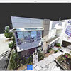
Photogrammetry

Menmento Site

R0010274_20160203124042
Aerial3D360
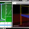
Introduction to Verity Construction Verification Software
Laser Scanning
CIM City Information Modelling
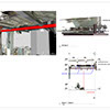
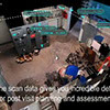
Laser Scanning for As-Built Drawings
Point Cloud
QR Scanning
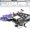
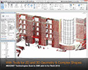
Point Cloud to BIM
Commercial Office Fit-Out Uses Laser Scans and BIM to Coordinate Work
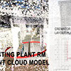
19031-WHS_Crematorium-Clash-Report
AI
Existing 2D Plan to Model

R0010274_20160203124042_er
帝景峰【無人機航拍建模視頻】
Photogrammetry results
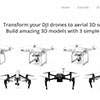
NovaPeak PFI & Drone Specialist
As-Built BIM Models from 3D Laser Scanning
SAM's Managed Geospatial Data™ BIM Capabilities
IMAGINiT Scan to BIM for Revit 2012
FARO kubit - PointSense para Revit
ReCap
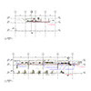
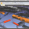
Drawing of Point Cloud Section for Clash

R0010016
Photogrammetry Project
UAV self detection
Laser Scanning As Built Conditions to Compare to Design Intent
3D Mapping - Intro to Drone Deploy | Flite Test
CBIMS模立方- Revit插件
Scan to BIM- Reduce Revit modelling time using EdgeWise
Additional I_Beam Demonstration Video
Advanced Construction Information Development Ltd.